Research: Robotics
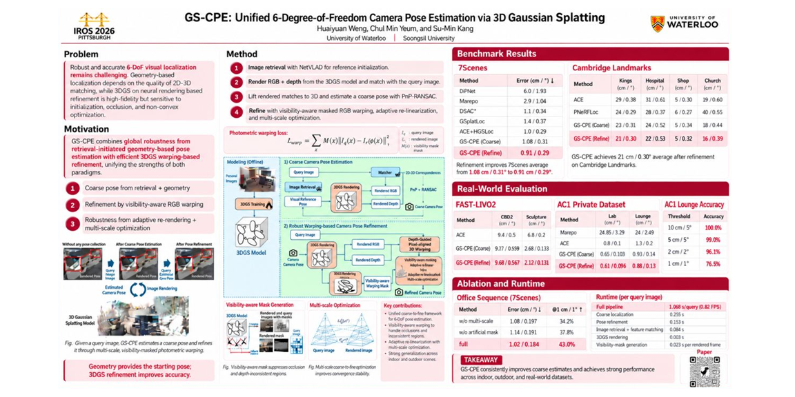
GS-CPE: Camera Pose Estimation with 3D Gaussian Splatting (IROS 2026)
On September 2026
Researcher: Huaiyuan Weng
Description: We introduce GS-CPE, a framework for estimating a camera’s 3D position and orientation using a 3D Gaussian Splatting scene representation. The method first obtains a coarse pose through image retrieval and geometric estimation, then refines it by aligning image content through 3DGS-based warping. Visibility-aware masking, multi-scale optimization, and adaptive re-rendering improve refinement robustness. Experiments on indoor and outdoor datasets, including 7Scenes, Cambridge Landmarks, and FAST-LIVO2, demonstrate improved localization accuracy and generalization.
Citation: Huaiyuan Weng*, Chul Min Yeum, and Su-Min Kang, “GS-CPE: Unified 6-DoF Camera Pose Estimation via 3D Gaussian Splatting,” IEEE/RSJ International Conference on Intelligent Robots and Systems (IROS), 2026.
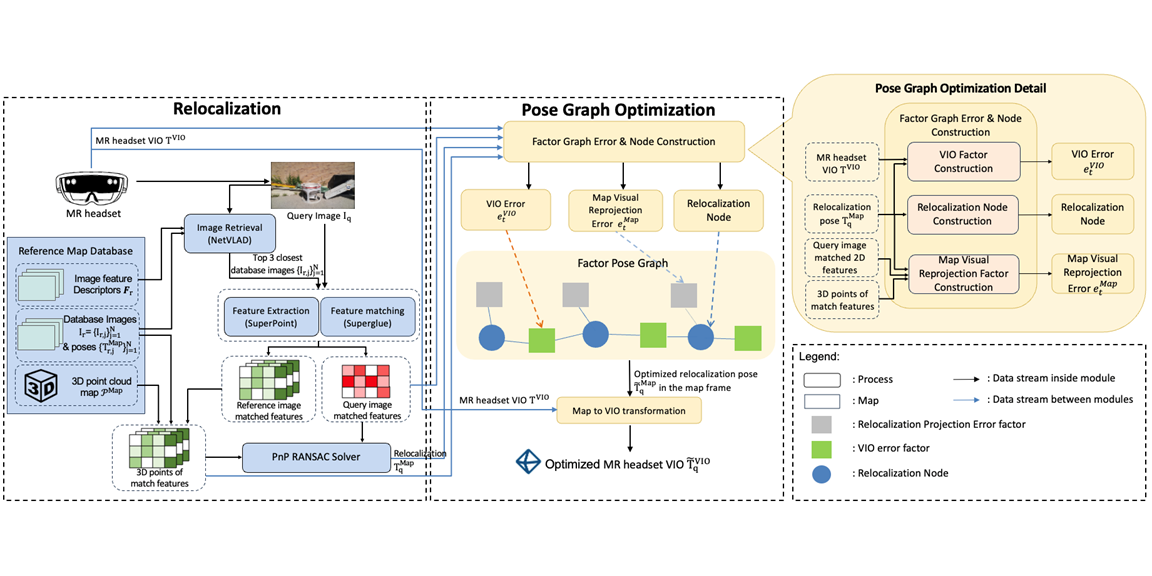
RPGO-MR: Accurate Mixed Reality Localization (AEI 2026)
On September 2026
Researcher: Huaiyuan Weng, Syed Muhammad Raza Rizvi
Description: RPGO-MR, an external framework that improves the alignment of commercial mixed reality headsets with pre-built 3D maps. It combines image-based relocalization, headset visual–inertial odometry (VIO), and map-based visual constraints in a sliding-window pose graph. Delayed relocalization results are incorporated at their original capture times, while high-frequency VIO updates maintain responsive pose output. Indoor and outdoor experiments reduced image-plane reprojection error by 12.65–16.3% relative to raw relocalization. The framework operates without access to the headset’s proprietary tracking internals.
Citation: Huaiyuan Weng*, Syed Muhammad Raza Rizvi*, Chul Min Yeum, Jongseong Choi, and Su-Min Kang, “RPGO-MR: Relocalization Pose Graph Optimization for Accurate and Latency-Aware Mixed Reality Localization,” accepted at Advanced Engineering Informatics (2026).
3DGS-Holo-Inspector: Mixed Reality UAV Controller with 3D Gaussian Splatting Localization (ICRA 2026)
On January 2026
Researcher: Syed Muhammad Raza Rizvi, Huaiyuan Weng
Description: We introduce 3DGS-Holo-Inspector, a mixed reality (MR) interface for intuitive UAV-based infrastructure inspection. Operators specify inspection goals using hand gestures in MR while a LiDAR–RGB 3D Gaussian Splatting map enables markerless headset–UAV localization indoors and outdoors. The UAV autonomously navigates to selected viewpoints with real-time telemetry visualized holographically. Experiments achieved localization RMSE of 0.090 m indoors and 0.119 m outdoors, demonstrating reliable and user-friendly MR control for field inspection tasks.
Citation: Syed Muhammad Raza Rizvi*, Chul Min Yeum, and Huaiyuan Weng*, “3DGS-Holo-Inspector: A Mixed Reality UAV Controller with 3D Gaussian Splatting Localization for Infrastructure Inspection,” accepted at ICRA 2026.
Advancing Architectural Visualization with Augmented Reality (FMA 2024)
On October 2025
Researcher: Jason Su
Description: This project explores how augmented reality (AR) enhances architectural visualization by improving perceived realism and scale. Using an iPhone-based AR application and game-engine rendering, virtual structures are placed directly into real environments with real-time lighting, shadowing, and occlusion. A pavilion case study demonstrates how AR enables designers and users to better understand spatial relationships compared to conventional 3D models, supporting more intuitive and immersive design evaluation.
Citation: Jason Su* and Chul Min Yeum, “Advancing Architectural Visualization: Boosting Scale and Reality with Augmented Reality,” 7th International Symposium Formal Methods in Architecture, Porto, Portugal, Dec 3–6, 2024.